
Topographical Survey London
Topographic survey services entail the production of plans and maps which are 100% accurate to scale. These maps are created to represent details of natural and built environments on a 1:1 scale.
Topographic surveys may be required to record building condition or to conserve historical records. These surveys can detail topography for engineering purposes and record the condition of a development at various stages, providing a highly accurate building record for control and certification.
Topographic Survey Services
If you are a property developer, land owner or architect planning on developing new property on your land, you are going to need a full topographic site survey which allows for highly precise measurements of land and all external features, without any corner cutting whatsoever.
With our unique topographic survey services, you can expect high-quality control, assurance and checks from our topographic land surveyors.
Topographic Land Surveyors
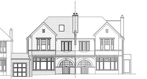
A proper topographic survey can easily establish floor, window and ceiling levels along with producing sections, plans and elevations.
Using equipment that includes the Leica Total Station, A&E Solutions provides a full topographic survey service in London. We can swiftly measure any feature of the natural environment or built to the highest standard possible.
Topographic Site Survey
We are a topographic survey company with a dedicated team of highly knowledgeable topographic land surveyors who will visit your site, gather the necessary data and then coordinate with our CAD technicians to design a 1:1 map drawing of the site.
